Preston Capes
Appearance
| Preston Capes | |
|---|---|
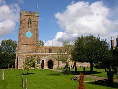
 St Peter and St Paul's Church in Preston Capes | |
Location within Northamptonshire | |
| Population | 216 (2011) |
| OS grid reference | SP5754 |
| Unitary authority | |
| Ceremonial county | |
| Region | |
| Country | England |
| Sovereign state | United Kingdom |
| Post town | Daventry |
| Postcode district | NN11 |
| Dialling code | 01327 |
| Police | Northamptonshire |
| Fire | Northamptonshire |
| Ambulance | East Midlands |
| UK Parliament | |
Preston Capes is a village and civil parish in West Northamptonshire in England. The population, including Canons Abbey, at the 2011 census was 216,[1] up from 188 at the 2001 census.[2]
The village's name means "Priest Farm/Settlement". The village was owned by Hugo filius Nicholai de Capes in 1234.[3]
The Church of England parish church is dedicated to St Peter and St Paul.
References
[edit]- ^ "Civil Parish population 2011". Neighbourhood Statistics. Office for National Statistics. Retrieved 30 June 2016.
- ^ Office for National Statistics: Preston Capes CP: Parish headcounts. Retrieved 18 November 2009
- ^ "Key to English Place-names".
External links
[edit]Wikimedia Commons has media related to Preston Capes.


